



There are two versions of this summer’s drought. The first is visible everywhere. It's in the yellow grass, the prematurely harvested fields and the cracks opening in the earth. It can be seen along the exposed margins of reservoirs and in our northern rivers diminished to a fraction of their customary summer flow.
The other drought is taking place below ground, beyond sight and largely beyond public consciousness.
Here the picture is a bit more complicated - and, for the moment, rather more hopeful.
Analysis by the British Geological Survey suggests that many of the aquifers beneath the UK have remained surprisingly resilient despite the exceptional heat and lack of rain above them. Of 35 groundwater monitoring sites included in its latest assessment, eight were notably below normal, while 15 remained within or above their normal historical range. None had reached a record low.
That's not a finding which permits complacency. But it does reveal something important about the quiet work performed by the rocks beneath us - and about the choices Britain will have to make as drought becomes a more regular part of national life.
Across northern England, the contrast is particularly striking.
In July, Yorkshire received only 6.6 millimetres of rain: just 10 per cent of its average for the month between 1991 and 2020. Northumbria received 23 millimetres, or 31 per cent of average, while the North West recorded 26 per cent.
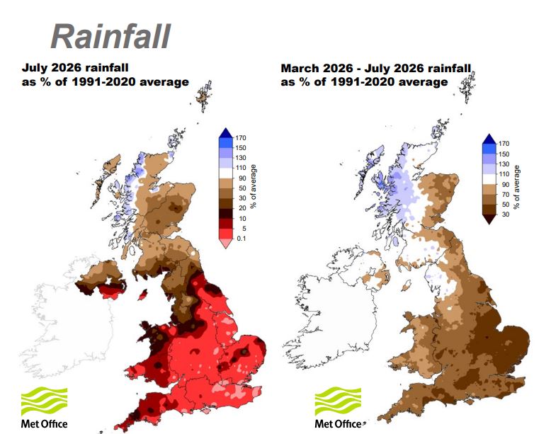
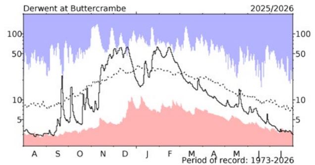
The Yorkshire Derwent registered its lowest July flow in a monitoring record extending beyond 52 years. Across England and Wales, the combined volume of water leaving rivers was the third-lowest for July in a record beginning in 1961, bettered only by the drought years of 1976 and 1984.
Yet some of the water stored underground was holding on.
An aquifer is sometimes imagined as an underground lake: a great concealed cavern filled with water. In reality, it is usually rock through which water can be stored and transmitted.
Rain percolates through soil and into pores, cracks and fractures within permeable rock. It accumulates below the water table and then moves slowly through the ground, sometimes emerging through springs or feeding rivers from beneath.
Northern England possesses a complicated geological patchwork.
The Chalk of the Yorkshire Wolds forms an important aquifer beneath East Yorkshire. Bands of Magnesian Limestone extend through parts of Yorkshire and County Durham. Carboniferous Limestone underlies much of the Pennines and the Yorkshire Dales, while large sandstone aquifers occur beneath areas of Cumbria and Northumberland.
Each behaves differently. Chalk can hold and transmit significant quantities of water through networks of fractures. Limestone might move water rapidly through fissures and underground channels. Sandstone stores water within the spaces between individual grains.
This geology doesn't respect water-company boundaries, county lines or political constituencies. Nor does it behave like a reservoir whose condition can be judged simply by looking over its wall.
Groundwater might take weeks, months or considerably longer to respond to events on the surface. That delay is one reason an aquifer can remain comparatively healthy while the surrounding landscape appears to be drying out.
It's also why the current data needs to be understood as a story partly written last winter.
In the UK we entered spring after a strong period of groundwater replenishment.
During the cooler months, vegetation uses less water and evaporation is reduced. Rain falling onto sufficiently wet and permeable ground can therefore pass down through the soil and replenish aquifers - a process known as recharge.
That wet winter gave many groundwater systems an elevated starting point before this summer’s extraordinary heat began drawing moisture out of soils, vegetation, rivers and reservoirs.
The aquifers, in effect, entered the drought with savings in the bank.
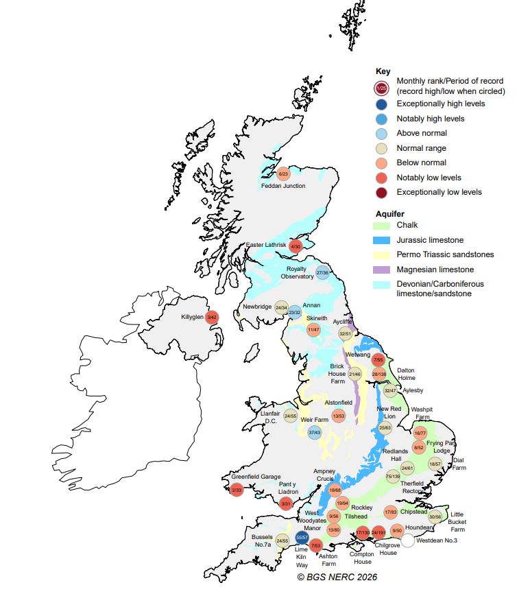
The British Geological Survey’s assessment found that groundwater levels were generally stabilising after their seasonal decline. In northern monitoring sites, the picture ranged from notably low levels in the Chalk at Wetwang and in the Carboniferous Limestone, to normal conditions around Aycliffe and above-normal levels in the Fell Sandstone at Royalty Observatory in Northumberland.
There is no single northern groundwater condition. The geology, preceding rainfall, local water use and relationship between an aquifer and the landscape above it all matter.
But the wider resilience is significant because the drought at the surface has developed with alarming speed.
The UK Centre for Ecology & Hydrology’s July assessment describes a “flash drought”: a rapid deterioration in which persistent low rainfall is intensified by very high temperatures.
Heat doesn't only accompany a drought. It accelerates it.
Water evaporates more quickly from soils and open water. Plants draw moisture from the ground. River flows decline, agricultural demand rises and the landscape becomes more vulnerable to fire. A country which appeared to have healthy water resources in early spring can find itself under acute pressure only a few months later.
July 2026 was the driest July in the England and Wales rainfall series stretching back to 1766, and the fifth-driest month of any name within that entire record. England experienced its second-hottest July on record.
It was also the third year in the past five in which drought impacts escalated rapidly following exceptional spring and summer aridity.
This is no longer easily dismissed as a single, freakishly dry season.
It's tempting to treat healthy aquifers as an invitation to pump more water.
Groundwater already provides around one-third of England’s public water supply, although the proportion varies considerably between regions. The BGS believes it could play a larger part in protecting the country during future periods of extreme weather.
There's a sound argument for managing surface water and groundwater as parts of one connected system. During wet periods, aquifers can store enormous volumes of water without the land take, evaporation losses and engineering required by a conventional reservoir.
During drought, carefully chosen boreholes could potentially supplement public supplies or support river flows.
But “water underground” doesn't mean “water without consequences”.
Aquifers are connected to the natural world above them. Groundwater emerging through springs sustains wetlands, streams and rivers. It can maintain flow during dry weather, regulating water temperature and providing a refuge for fish, invertebrates and aquatic plants when rainfall disappears.
Pump too much from the wrong place at the wrong time and the water table can fall. Springs can weaken. Wetlands might dry out. A river already experiencing drought can lose the cool, steady baseflow that might otherwise keep parts of its ecosystem alive.
The question is therefore not only how much groundwater exists, but how much can be taken, from where, at what time and with what consequences.
That distinction matters in the Yorkshire Wolds, where the Chalk aquifer supports public supply, farming and groundwater-dependent habitats. New BGS geological mapping of the area has been created partly because changes in the thickness and character of the Chalk affect how groundwater moves and where the aquifer may be vulnerable to pollution.
The rocks beneath East Yorkshire are not one uniform underground tank. Understanding their structure is essential if they're to be managed safely.
Our public understanding of water remains dominated by reservoirs.
A reservoir is legible. When its level falls, the crisis is visible. Photographs of exposed shorelines and long-submerged structures can communicate scarcity in an instant.
Groundwater offers no equivalent spectacle. Its decline takes place down boreholes, measured against long historical records and translated into charts by hydrogeologists.
That invisibility has consequences. It allows groundwater to be overlooked when water infrastructure's debated. But it can also encourage the dangerous belief that an aquifer is an untouched reserve which can simply be called upon when everything else begins to fail.
The current BGS figures should be read as evidence of resilience, not abundance without limit.
Eight of the monitored sites were already notably below normal at the end of July. The groundwater outlook suggested normal to below-normal conditions over the following three months. And the relative strength of many aquifers remained heavily dependent upon the preceding wet winter.
Remove that winter recharge and the same summer could produce a much more serious outcome.
A sequence of dry winters and hot summers would progressively empty the geological savings account. Because groundwater systems respond slowly, some can also take a long time to recover after severe depletion.
What appears robust in one exceptional summer might prove much less secure across several consecutive years.
Britain’s water problem isn't simply that too little rain falls. It's that rain increasingly arrives at the wrong time, in the wrong place or with an intensity that makes it difficult to capture.
Long dry periods might be interrupted by sudden downpours falling onto hard, desiccated or urbanised ground. Instead of soaking gradually into soil and replenishing aquifers, water runs rapidly into drains and rivers, sometimes producing flooding without repairing the underlying deficit.
A more drought-resilient North will therefore require more than new boreholes.
It will mean restoring peatlands and wetlands which slow water’s passage through a landscape. It will require healthier soils capable of absorbing rainfall, more permeable space in towns and cities, reduced leakage from the supply network and greater storage at different scales.
It should also involve deliberately replenishing aquifers during wet periods - using carefully treated surplus water and suitable geology to store water underground for later use. Managed aquifer recharge is already employed in a number of water-stressed parts of the world, although it demands close control of water quality and a detailed understanding of what lies beneath the surface.
The more immediate lesson is one of integration.
Rivers, reservoirs, soils, wetlands and groundwater shouldn't be managed as separate assets brought into play one after another as each begins to fail. They belong to the same hydrological system, and decisions made in one part inevitably affect the others.
Groundwater could become a more important part of northern water security. But its value lies partly in what it already does without us noticing: feeding rivers, sustaining habitats and preserving water from one season to the next.
There's something reassuring about the discovery that, beneath a scorched landscape, water laid down during the winter is still moving through northern rock.
It's evidence of the buffering power of geology. Aquifers can soften the impact of extremes which transform rivers and fields in a matter of weeks. They offer options that an increasingly drought-prone country can't afford to ignore.
But the reassurance comes with a warning. This summer’s groundwater resilience was inherited from wetter months. It doesn't tell us that northern England is immune to drought. It tells us that natural storage has bought us time.
How that time is used will be key. We can regard the water beneath our feet as another reserve to be exploited when reservoirs run low. Or we can recognise it as part of a living system which needs to be understood, replenished and protected.
The first approach might help us through a summer.
The second might help prepare the North for the climate that is already arriving.
Header image: Groundwater Cross section (MagNorth)





